
Key Takeaways:
|
Want to stand atop a limestone peak and watch the sunrise?
In Vietnam, you can do that along with watching the mist drift over green rice terraces while you get a countryside moment.
Vietnam is increasingly popular among trekkers. The trails are as great as those in Nepal’s Annapurna region, with mountains, valleys, villages and forests, but with fewer crowds and more affordable costs. That’s why hiking is included in many travellers’ itineraries.
This country stretches from China to the Gulf of Thailand, offering travellers a variety of landscapes, rice terraces, mountain peaks, coastal jungle trails, and limestone karsts.
Quick Overview of Vietnam’s Top Hiking Trails
|
Trail Names |
Approx. Distance in Kilometres | Approx. Time | Difficulty |
| Fansipan | 22 – 28 km | 2 days | Hard |
| Ha Giang Loop Hikes | 2 – 12 kms | 2 – 5 hours | Moderate |
| Pu Luong Nature Reserve | 8 – 20 kms | Half-day to full-day | Moderate |
| Cat Ba Island | 3 – 15 kms | 2 – 7 hours | Easy – Moderate |
| Dalat Countryside Trails | 5 – 20 kms | 3 – 6 hours | Easy – Moderate |
| Phong Nha-Ke Bang National Park | 20+ kms | Half-day to multi-day | Moderate – Hard |
| Hoang Lien Son Mountain Range | 30+ kms | 3 – 4 days | Hard |
| Cuc Phuong National Park | 5 – 12 kms | 3 – 5 hours | Easy – Moderate |
| Bach Ma National Park | 3 – 10 kms | 3 – 6 hours | Moderate – Hard |
| Cat Tien National Park | 10 – 12 km | Half-day to multi-day | Moderate – Hard |
Why Hiking is Popular in Vietnam?
While many destinations focus on natural scenery, Vietnam’s trails also offer deep cultural immersion. Especially Sapa has many interesting things, as many trails pass through villages where ethnic minority groups still maintain their way of life.
You can interact with the locals, learn about their day-to-day practices, and then gradually work up to the panoramic views.
Tip: Download the Maps.me app before your trip. Cell phone service in Vietnam’s mountains can be unreliable, but this app works without an internet connection and shows hidden trails, homestays, and viewpoints that are not listed on Google Maps.
Recommended Operators for Hiking in Vietnam
- Jungle Boss Trekking Tours Headquarters
- Mộc Nam Adventure
- Sapa Sisters
- Trekking Tour Sapa
- Mr Linh’s Adventure
- Oxalis Adventure Tours
- Itrek Travel
The Best Hiking Places in Vietnam
The mountains in Vietnam span 1,650 kilometres from China to the Gulf of Thailand, and the country’s 54 ethnic groups inhabit highland regions. These factors led to a network of footpaths connecting villages, rice fields, and local markets.
Today, these same trails provide some of the best hiking options, ranging from easy two-hour walks to week-long journeys.
1. Fansipan Mountain (Sapa)
Fansipan stands at 3,143 metres, making it the highest peak in Indochina. Visitors who prefer a quick ascent can take a cable car to the summit in about 20 minutes.
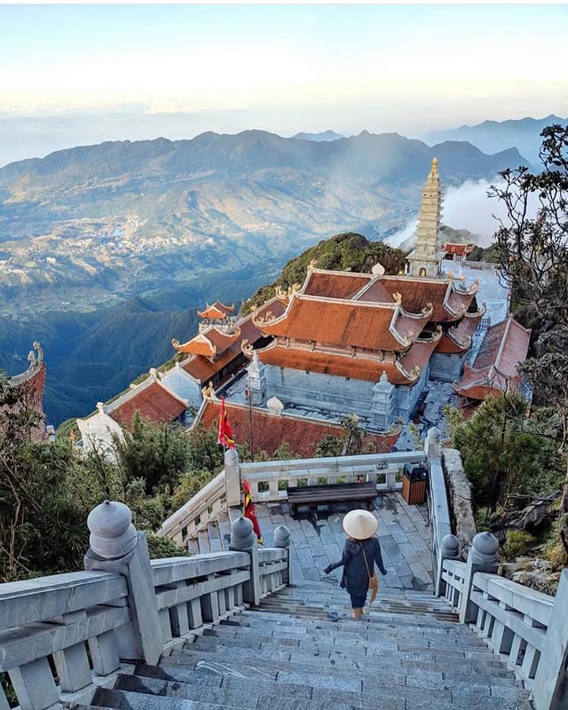
However, the two-day trek is one of the most popular trekking trails in Vietnam for its diverse landscapes.
This route begins at Tram Ton Pass with a vertical climb of 1,243 metres, passing through bamboo forests, subalpine conifers, and alpine meadows. At the end, you will reach the rocky summit.
Note: Hiring a guide is required, as trekking alone is unsafe due to unpredictable weather.
2. Ha Giang Loop
The Ha Giang Loop, located 320 kilometres north of Hanoi, is renowned for its dramatic karst landscapes and cultural richness.
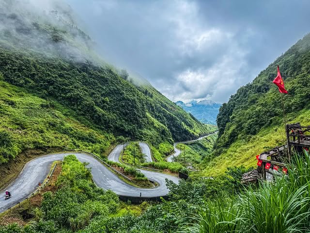
Most travellers explore the Ha Giang Loop by motorbike for three or four days, but hiking options include well-maintained village paths and challenging mountain trails.
The landscape of Ha Giang is truly remarkable, with limestone formations rising over 500 metres above the valleys.
Hiking routes in the Ha Giang Loop
- Lung Cu Flag Tower: The route ascends 200 metres and passes through Lo Lo ethnic villages, offering impressive views across the border into China.
- Hoang Su Phi Rice Terraces: Village-to-village treks passing through some of Vietnam’s most scenic terraced landscapes.
- Khuoi My Village: A two- to three-hour trek from Dong Van leads through terraced valleys to this secluded Hmong village, where traditional stone houses and cultural practices are still preserved.
Note: A travel permit is mandatory and costs approximately 180 INR. It can be obtained from the Ha Giang City Police Station or through a tour operator.
3. Pu Luong Nature Reserve
Pu Luong Nature Reserve lies about 137 kilometres south of Hanoi. This 17,662-hectare reserve features dramatic limestone mountains, ancient forests, and traditional Thai ethnic villages surrounded by terraced rice fields and bamboo water wheels.
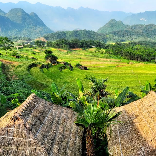
The main trekking routes in Pu Luong offer breathtaking scenery and a genuine glimpse of rural life.
Here are a few trails in Pu Luong Nature Reserve
- Don Village Loop: It takes you through rice terraces and a bamboo forest.
- Hieu to Lan Village trek: This is challenging, as you have to cross mountainous, dense forest where wildlife such as macaques, flying squirrels, and many bird species can be spotted.
- Kho Muong to Uoi Village trail: Follows mountain streams and features swimming spots and waterfalls.
Note: While permits are not required, hiring a local guide is highly recommended in Pu Luong Nature Reserve for navigating the trails and organising homestays.
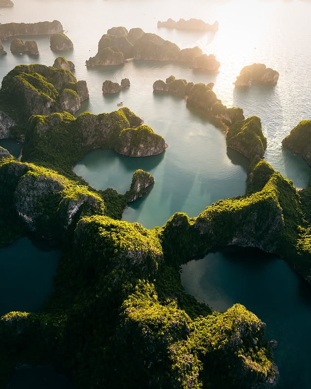
4. Cat Ba Island
Cat Ba Island is located near Hai Phong Province, about 150 kilometres from Hanoi and 30 kilometres from Hai Phong.
This island is home to Cat Ba National Park, which covers 263 square kilometres. The park features dramatic limestone mountains, dense tropical forests, and mangrove areas.
It is also the final refuge for the rare Cat Ba langur, a golden-headed monkey with only 65 to 70 individuals left.
Cat Ba is more than just a nature reserve; it offers many activities for visitors. You can hike, climb rocks, paddle through caves, or snorkel around the islands of Lan Ha Bay, which has over 300 limestone islands in clear blue water.
Recommended hikes in Cat Ba Island
- Ngu Lam Peak: The path takes you 331 metres to the top through farmland and villages, but becomes steep with stone steps.
- Hospital Cave to Frog Lake: The hike takes two to three hours and combines history with nature.
- Cannon Fort Circuit: The path leads to a hilltop fort with large artillery guns left from the French and American periods.
- Kim Giao Forest Trek: The hike is challenging, involving travel through dense forest and up steep hills.
5. Dalat Countryside Trails
Dalat is often described as Vietnam’s alpine-style hillshaped by its French colonial heritage. The area features pine forests, flower gardens, temperate vegetable farms, and a consistently cool climate, with temperatures ranging from 15 to 24°C year-round.
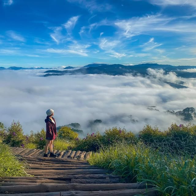
The hiking trails here are suitable for beginners, as they are clearly marked, with signs in English.
Recommended hike spots in Dalat
- Langbiang Mountain: The trail begins at Lat Village, home to the K’Ho people, and the trail passes through pine forests, strawberry fields, and flower greenhouses.
- Datanla to Pongour Falls Trek: The trail travels through pine woods and coffee plantations, linking Dalat’s two most impressive waterfalls.
- Tuyen Lam Lake Circuit: You will be passing through pine forests and quiet villages. The route is mostly flat and suitable for families with kids.
- Bidoup Nui Ba National Park: For those seeking a more challenging hike, Bidoup Peak takes you through an undisturbed cloud forest.
6. Phong Nha-Ke Bang National Park
Phong Nha-Ke Bang National Park is located about 500 kilometres south of Hanoi.
This national park is known for its ancient karst mountains, which are over 400 million years old and contain more than 300 caves hidden under the jungle. The most famous of these is Son Doong, one of the world’s largest cave chambers.
Visiting Son Doong is expensive, and tours often need to be booked six to twelve months in advance. However, there are many other exciting cave tours available in the park.
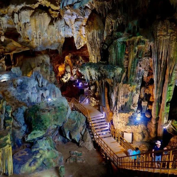
Note: Book your cave tour through the Oxalis Adventure website well in advance, as they are the only tour operators permitted to lead expeditions into restricted areas, and their guides are highly knowledgeable.
Famous trekking options in Phong Nha-Ke Bang National Park
- Hang En Cave: This is the third-largest cave chamber in Vietnam, with a unique jungle ecosystem.
- Tu Lan Cave System: This trip takes you to various caves, with activities including swimming across rivers, trekking through the jungle, climbing over rocks, and jumping into deep pools.
- Hang Va Cave: This trail suits experienced adventurers. It combines the Tu Lan caves with Hang Nuoc Nut, where you swim 400 metres through a river in the dark, and ends in Hang Va, known for its rare cave pearls.
7. Hoang Lien Son Mountain Range
Located in Northwest Vietnam, the Hoang Lien Son range offers much more than just the famous Fansipan peak. This area has 26 other mountains rising above 2,500 metres, including notable peaks such as Bach Moc Luong Tu, Ngu Chi Son, and Pu Ta Leng.
Trekkers need to be skilled in navigation and prepared to climb these challenging peaks. The biodiversity is remarkable, with rare animals such as the Tonkin snub-nosed monkey and possibly red pandas.
Trek routes in Hoang Lien Son Mountain, Vietnam
- Bach Moc Luong Tu: This is a challenging 4 to 5-day trek starting from Y Ty village in Lao Cai province. The route passes through Red Dao villages, bamboo forests, cloud forests, and open grasslands.
- Pu Ta Leng: The 3 – 4-day hike starts in Lai Chau town and passes through Hmong and Dao villages, with beautiful trees blooming in March and April. The trails are wild and scenic.
Note: These trips are not simple hikes. Permits are required, but the operators will arrange these with local authorities.
8. Cuc Phuong National Park
Established in 1962, Cuc Phuong National Park is Vietnam’s oldest national park, covering 22,200 hectares. The park is important for both its natural beauty and rich biodiversity.
The park is home to 135 mammal species and 340 bird species.
An entrance fee is required for the park, which can cost approximately 207 INR. A guide can help you spot more wildlife and navigate to prime viewing locations.
Major hiking trails in Cuc Phuong National Park
- Ancient Tree Circuit: The trail goes through rainforest, where you can see Parashorea chinensis trees that are over a thousand years old and can reach 70 metres in height.
- Mac Lake Trail: It passes through the forest to a seasonal lake, which may be full or dry depending on the time of year.
- Cave Loop: This is for those who enjoy adventure. It leads to Nguoi Xua Cave, where ancient human remains were found, and to Con Moong Cave.
9. Bach Ma National Park
Bach Ma National Park lies 65 kilometres from Da Nang and rises to 1,450 metres above sea level.
The highlight of this place is that in the 1930s, the French built over 130 villas here to escape the coastal heat. Now these villas stand as atmospheric ruins, open for exploration.
The park has an entrance fee of approximately 207 INR, with an additional vehicle fee of approximately 587 INR. Most visitors drive to the summit area and then hike down or take the trails around the park.
Top hiking trails in Bach Ma National Park
- Summit Trail: This trail is a 1.9-kilometre round-trip if you follow the old French road.
- Do Quyen Waterfall Trek: This trail is about 8 kilometres round-trip through the forest to Vietnam’s tallest single-drop waterfall, which is 300 metres high.
- Pheasant Trail: A short 3-hour trail is specially designed for birdwatchers.
10. Cat Tien National Park
Cat Tien National Park is located in Dong Nai Province, about 150 kilometres northeast of Ho Chi Minh City. It is home to a wide variety of wildlife, including Asian elephants, Indochinese leopards, wild water buffalo, sun bears, and more than 360 bird species.
Visitors trek through diverse landscapes, including jungle trails and wetlands, with basic camping available.
The entrance fee is about 208 INR, and the guide costs approximately 1,700 INR.
Main trekking routes in Cat Tien National Park
- Crocodile Lake Expedition: This is a 2-day trip to a remote wetland lake home to endangered crocodiles and many waterbirds.
- Heavenly Rapids Trail: This route takes you to natural pools and rapids along the Dong Nai River.
- Ta Lai Longhouse Circuit: Hike through lowland forest, passing by a traditional Chau Ma ethnic longhouse.
Conclusion
Hiking in Vietnam is more than a simple walk through nature; it is an adventure that reveals the diversity of Southeast Asian landscapes and cultures
Imagine walking along Ta Xua’s famous “dinosaur spine” as clouds move across the mountains, or sharing rice wine with H’mong families and staying overnight in their homes.
If you want to experience nature and tribal life in the mountains, hiking in Vietnam is the best choice.
Also, trekking in Vietnam is not a simple activity, as it requires guides and permits for certain locations. If you want to include any of the above-mentioned trekking activities in your next trip, talk to our Vietnam travel planner and get a customised itinerary.
FAQs on Hiking in Vietnam
1. When is the best time to hike in Vietnam?
- Northern Vietnam: October to April offers the best conditions, with cool, dry weather, ideal for the Sapa, Ha Giang, and Ba Be trails. From September to October, the rice terraces are golden, and it’s the harvest season.
- Central Vietnam: February to July provides dry weather for Bach Ma and Phong Nha cave treks. November to January brings heavy rain, but waterfalls in Vietnam are at their most impressive.
- Southern Vietnam: December to April is ideal for Cat Tien and Nui Chua with moderate temperatures. May to September is monsoon season, which makes southern trails muddy but increases wildlife activity near water sources.
2. Do you need a guide, and how much does it cost?
It depends on the location. On well-known trails like Langbiang near Dalat, Ngu Lam on Cat Ba Island, or Cuc Phuong, you can hike alone.
For remote areas such as Ha Giang, Pu Luong, or ethnic villages, you need a registered guide, which usually costs 1,000 to 2,500 INR per day. For a multi-day trek, the cost can exceed 15,000 INR.
However, guide fees typically include everything you need. Guides do more than just show the way; they help with local customs, arrange homestays, point out wildlife, and keep you safe.
3. How physically fit should you be for Vietnam hiking trails?
Different trails require different capabilities; some are best suited for beginners, and some are for those with good physical fitness.
Hiking trails in Vietnam for different levels
- Beginners: Cat Ba’s Ngu Lam Peak, Dalat’s Langbiang, and Mu Cang Chai’s terraces.
- Basic Fitness: Pu Luong, Fansipan, and Bach Ma.
- Advanced: Bach Moc Luong Tu, Ta Xua’s dinosaur spine, or Crocodile Lake
4. What permits are required for hiking in Vietnam, and how can you obtain them?
Most trails require only national park entrance fees, which cost approximately 200 – 550 INR, purchasable at gates.
Treks like the Ha Giang Loop require a travel permit due to proximity to the Chinese border. You can get them through tour operators, guesthouses, or police stations, with a passport copy.